We are not really walkers or cyclists and don’t in anyway pretend to be or aim to provide experienced advice, paths and access can be changed at any point, weather conditions can severely change what would normally be a safe route to take and therefore strongly advise that you use the information we provide as a guide only, do your research and ensure you are adequately prepared before you set off, ensuring someone knows where you have gone and your phone is fully charged (be aware coverage may be limited when you need it).
We are starting to do more walking and cycling routes and have decided to track these on a separate map (at the bottom of the page), with more details below. In January 2017 both myself and my wife bought Fitbit trackers and the Fitbit app allows you to track a walk using your phones GPS, however having had issues with the Fitbit App, I prefer to stick to tracking using my i-gotU tracker. One other thing I really enjoy is boating and you can check out our Norfolk Broads trip here and York Marina here, so I have decided to track boat trips/rides and add these to this map also.
Walked Routes (including attractions) are in Green
Cycled Routes are in Red
Boat Trips/Rides are in Blue
Special/Event Routes are in Purple
Walking routes we plan to do are in black
Walks
Fountains Abbey – March 2020
What a fantastic place, paths are very good and wheelchair/pushchair friendly, although some sections are quite steep, but you don’t have to take those paths. The views of the Abbey are fantastic and you can really get in amongst the ruins, loads of space for a picnic on the grass and great for families, including large park, can easily spend a full summers day there.
What a fantastic place, paths are very good and wheelchair/pushchair friendly, although some sections are quite steep, but you don’t have to take those paths. The views of the Abbey are fantastic and you can really get in amongst the ruins, loads of space for a picnic on the grass and great for families, including large park, can easily spend a full summers day there.
Newmillerdam Country Park – March 2020
The paths around Newmillerdam are fairly flat and even and would be fine for wheelchairs and buggys, it took us about 1 hour, sticking mostly to the main path, however there are some other paths through woodland.
The paths around Newmillerdam are fairly flat and even and would be fine for wheelchairs and buggys, it took us about 1 hour, sticking mostly to the main path, however there are some other paths through woodland.
Rabbit Ings Country Park - March 2020
This a beautiful, peaceful place to walk around, with a few different routes to choose from, on our first visit we did the red route. The paths are fairly even, but are made from rough stones and there’s also a few steep sections, which would be difficult for a wheel chair. We did the red route in around 45 minutes, although we couldn’t entirely follow the full red route, as the lake had flooded across the path, which at the time we didn’t realise was blocking the extension part of the red route.
This a beautiful, peaceful place to walk around, with a few different routes to choose from, on our first visit we did the red route. The paths are fairly even, but are made from rough stones and there’s also a few steep sections, which would be difficult for a wheel chair. We did the red route in around 45 minutes, although we couldn’t entirely follow the full red route, as the lake had flooded across the path, which at the time we didn’t realise was blocking the extension part of the red route.
Anglers Country Park – July 2019
There’s a pay & display car park, £1 for 2 hours and depending on the individuals walking pace, 2 hours should be enough to get around once, we did the approximately 2-mile walk in about 1 hour and we are certainly not fast walkers. There’s also a visitors centre, where you can buy an activity pack for the room on a broom adventure trail, as you walk the trail, kids can find figures and places to take rubbings of metal shapes mounted on posts, all part of the activity pack.
The paths mostly follow the lakeside, only detouring away from the lake for about a ¼ of the walk and the path around the lake is both wheelchair and pushchair friendly. A nice place for a gentle walk around a beautiful lake or if you want you could do another lap or maybe even bring your bike.
Worsbrough Country Park
We were originally looking for a café/tearoom in a nice location to go for lunch, when we cam across Millers Tea Room, which is conveniently located at the Worsbrough Country Park. Having had some lunch, we then went for a walk, there are 3 routes you can choose from,
We initially chose the red/Badger route and it should be easy to follow, as there are signposts with coloured arrows, however at the first junction of the red/blue route, we decided we’d do part of the blue route, (there are 2 sections where the blue route deviates off the red route, so we could do one deviation and then stick to the red route), so instead of turning right we carried on.
We had seen some signs for a bridge that was closed, but we didn’t know where the bridge was and there was no mention of it affecting the walking routes, but we did end up passing the closed bridge. We didn’t know it at this point, but that closed bridge was where we needed to turn to meet back up with the red route, however we didn’t see any signposts at the time and with it being closed it looked like the path continued ahead. Continuing the path we went past another gate, again no signs and at first glance didn’t look right, however carrying on the path got narrower and more overgrown, we eventually reached a point where we couldn’t get through and turned back. You can see from the map of our route in the below slideshow how far we went, we came back to the gate and went through it, meeting up with some more paths, before arriving at the junction where we should have come out to meet the red route, had the bridge not been closed.
The remainder of the route was straight forward, and we decided to make a stop at Wigfield farm, which is also conveniently positioned with only minimal deviation from the walk, you can check out our review, pictures and videos from Wigfield Farm here.
After our visit to the farm, we picked up where we left off and finished the reminder of the route, taking the yellow/fox route over the reservoir bridge, so we ended up doing none of the official routes, more a mix of all with unnecessary extra added in. It’s an ideal place for all to go for walk that suites, visit the farm and stop for refreshments.
We were originally looking for a café/tearoom in a nice location to go for lunch, when we cam across Millers Tea Room, which is conveniently located at the Worsbrough Country Park. Having had some lunch, we then went for a walk, there are 3 routes you can choose from,
- Yellow/Fox which is the shortest at approx. 2km which is also suitable for wheelchair/pushchair access
- Red/Badger at approx. 3.5km and suitable for wheelchair/pushchair access
- Blue/Owl at approx. 5km, not suitable for wheelchair/pushchair access and can be muddy in wet weather
We initially chose the red/Badger route and it should be easy to follow, as there are signposts with coloured arrows, however at the first junction of the red/blue route, we decided we’d do part of the blue route, (there are 2 sections where the blue route deviates off the red route, so we could do one deviation and then stick to the red route), so instead of turning right we carried on.
We had seen some signs for a bridge that was closed, but we didn’t know where the bridge was and there was no mention of it affecting the walking routes, but we did end up passing the closed bridge. We didn’t know it at this point, but that closed bridge was where we needed to turn to meet back up with the red route, however we didn’t see any signposts at the time and with it being closed it looked like the path continued ahead. Continuing the path we went past another gate, again no signs and at first glance didn’t look right, however carrying on the path got narrower and more overgrown, we eventually reached a point where we couldn’t get through and turned back. You can see from the map of our route in the below slideshow how far we went, we came back to the gate and went through it, meeting up with some more paths, before arriving at the junction where we should have come out to meet the red route, had the bridge not been closed.
The remainder of the route was straight forward, and we decided to make a stop at Wigfield farm, which is also conveniently positioned with only minimal deviation from the walk, you can check out our review, pictures and videos from Wigfield Farm here.
After our visit to the farm, we picked up where we left off and finished the reminder of the route, taking the yellow/fox route over the reservoir bridge, so we ended up doing none of the official routes, more a mix of all with unnecessary extra added in. It’s an ideal place for all to go for walk that suites, visit the farm and stop for refreshments.
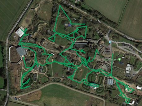
Twycross Zoo - June 2019
I know not everyone will class walking around a zoo as a “going for a walk”, but for those like us who are not necessarily interested in doing an intense walk or what something else of interest other than views, a zoo is an enjoyable walk and with over 16,000 steps in the day, I think it classifies. Below is a map showing our route around the zoo, as expected it looks a little messy. For review, pictures and videos from our visit to Twycross Zoo, please see our Twycross Zoo page here
I know not everyone will class walking around a zoo as a “going for a walk”, but for those like us who are not necessarily interested in doing an intense walk or what something else of interest other than views, a zoo is an enjoyable walk and with over 16,000 steps in the day, I think it classifies. Below is a map showing our route around the zoo, as expected it looks a little messy. For review, pictures and videos from our visit to Twycross Zoo, please see our Twycross Zoo page here
Helmsley - April 2019
We had visited Helmsley before, but never really fully explored this beautiful little village, so this time I did some online research for walks, we already knew of the walk along the Cleveland Way to Rievaulx Abbey, however we wasn't looking for as long a walk as that. We ended up parking in the long stay car park and from there we headed to the Helmsley Walled Garden, stopped for a cuppa and then headed past the car park and along the cleveland way, turning back when we reached the second gate through the field of sheep. We headed back down the cleveland way to the main road and then followed the road to the right, heading into the market square, we then just headed down the high street, back up through the shops before heading away from the market square, around to walk up the side of the river along Castlegate, before turning off towards the castle and back to the long stay car park. It's a lovely route to take, we would definitely recommend stopping off a the walled garden cafe for a break and if you decide to head along the cleveland way, bear in mind the section we did was very uneven and uphill. You can see a map of our route in the below slideshow.
We had visited Helmsley before, but never really fully explored this beautiful little village, so this time I did some online research for walks, we already knew of the walk along the Cleveland Way to Rievaulx Abbey, however we wasn't looking for as long a walk as that. We ended up parking in the long stay car park and from there we headed to the Helmsley Walled Garden, stopped for a cuppa and then headed past the car park and along the cleveland way, turning back when we reached the second gate through the field of sheep. We headed back down the cleveland way to the main road and then followed the road to the right, heading into the market square, we then just headed down the high street, back up through the shops before heading away from the market square, around to walk up the side of the river along Castlegate, before turning off towards the castle and back to the long stay car park. It's a lovely route to take, we would definitely recommend stopping off a the walled garden cafe for a break and if you decide to head along the cleveland way, bear in mind the section we did was very uneven and uphill. You can see a map of our route in the below slideshow.
St Aidan’s Nature Reserve – February 2018
We parked in a little car park off Fleet Lane and walked over the bridge to cross the Rive Airer, which is almost directly at the opposite side of the St Aidan’s Nature Reserves main car park.
There are some coloured routes you can walk within the reserve, which can be seen on some maps around the reserve and shown in our photo slideshow below. We chose to head up to the main car park, where there is a small visitors centre, where you can find toilets, seating inside and out, hot drinks machine and fridge with selection of sandwiches in.
After leaving the visitors centre we walked past the car park and headed away with the lake on our right, aiming to pick up an outer path we’d seen on google maps. It started out as a road and then into a path, which followed the river, but was fenced off from the reserve.
The paths within the reserve are wide enough and solid under foot, however when we visited in February 2018. It was very muddy on all the paths, so advisable to wear sensible walking boots/shoes in the wetter months.
Bolton Abbey - May 2017
We’d found a circular walk online from Bolton Abbey, which took you along the riverside and strid and then back down the other side of the riverbank back to the Abbey, but there was no map and we’d never been to Bolton Abbey before.
Arriving at Bolton Abbey we parked in the main car park (£10 per car) at the village and following the directions we headed left out of the car park and along the roadside, through the archway that was built across the road and then heading right at the Cavendish Memorial took us down some steps to an open field at the bottom. From here we headed straight across to the riverside and then through one of the other car parks right at the side of the river, where many people were doing a BBQ. At the end of the car park, we realised the instructions weren’t totally necessary and made some parts more confusing than necessary, if you check out the details provided by Bolton Abbey and the maps, you could just follow the coloured arrows, there are some sections where the path forks, so you need to know which route your following, but most of them lead you back to the main path anyway.
This first part of the walk the paths were made up of a compacted rough gravel, wide enough most of the time, sections did go up and down, but they were generally ok. We followed the path along the riverside and up to Barden Bridge, where we crossed the bridge to go back down the other side. After stopping for some lunch, we continued along and for a short while it was flat, but we soon arrived at the woods, it was at this point the path started to get rougher and this section through the woods was continually going up and down, weaving its way along with some relaxing views through the trees of the strid and river, but harder than the first section.
Eventually you can see the long car park on the riverside opposite, before you then finally see the abbey in view, before reaching the bottom, where you can either take the bridge across or if there’s not a continuous follow of people coming from the other side, you can also choose to go across the river via the stepping stones.
At the other side the abbey is right in front of you, from here we headed straight up with the abbey on our right and after a section of stairs, we arrived back at the roadside we’d walked along earlier. It was a nice walk to do, (you can view our route in the slideshow below), but it would also be nice to park up at the side of the river, get out the chairs and relax and there’s space for the kids to run around.
York City Walls – April 2017
We had never visited York before and walked the city walls and having seen it mentioned online when searching for walks, I thought it was one we should do. We parked at Foss Island as we usually do, the wife noticed there had been a price increase form £1.10/hr to £1.30/hr) and headed towards the centre, climbing the stairs up onto the wall, which we immediately realised meant we could only go clockwise, so which way ‘round decision made.
It wasn’t long before we had completed our first section along the city wall and found ourselves looking at the map to work out the direction we needed to head to get back on the walls, it was at this point the wife noticed the small circular gold marker on the floor, which was a great idea to help you navigate the streets to get to the next section of the wall.
As you walk along the walls, you will find sections that are quite narrow, the higher sections and sections above roads have railings, however some sections don’t, so you do need to watch where you are going and keep an eye on the kids (dogs are not permitted along the walls).
Although there are the small circular markers on the floor to guide you, it’s not always easy to find one and although there were several maps, it wasn’t always clear, as we came down from the walls on to Piccadilly, where it meets Tower St, we knew we had to cross the road and head around to Clifford’s tower, but it wasn’t until we’d walked all the way around and started looking on the floor for a marker, we eventually spotted one, suggesting we cross the road again and into Tower Gardens and I almost started to walk down the diagonal path, when my wife told me I was going the wrong way, as she’d seen another marker, (this actually only took us around the edge of Tower Gardens).
We carried on following the markers and back along the wall and we crossed back over the river and came into the Yorkshire Museum Gardens, a perfect time to stop and have our sandwiches. The gardens are lovely to walk around and following the path around, you come to St Mary’s Abbey or sadly what’s left of it. At this point we took a guess at the direction we needed to head to get back to the walls and through an archway into the York Explore Library Learning Centre my wife spotted a marker, but then there were no more, so we actually headed alongside the wall to a dead end, as we couldn’t see any more markers we headed past the York Explore Library Learning Centre and back to the road, following it around, before finally spotting some stairs back up onto the wall.
The last leg of our city walls walk took us past York Minster, sadly and not surprisingly not as close as we’d like, but there were some really nice views of beautiful gardens.
It took us just under 2 hours to do the walk (route shown in picture slideshow below), there’s some better or shall we say nicer sections of the city walls to walk along, some nice views, plenty of stairs and a few more markers/signs would help. In summer I suspect they get very busy and therefore probably making it not as enjoyable to walk along, so I would recommend getting there early to do the walk and then have a wander around the shops and go get a well earned drink.
Temple Newsam – April 2017
Another place we have visited on several occasions, Temple Newsam is a great place to take the kids, with acres of open fields and a farm, but on previous visits we’d not done a lot of walking around the grounds and on the visit I realised just how big it is.
Being such a lovely day and the first really warm day of 2017, we knew it would be busy, so we opted to park just off Selby Road on a residential street and walk in (via the shop for a bottle of water), however when we got there, there were loads of cars just parked on the grass. The route we did, was a circular route around the grounds (route walked in picture slideshow) and apart from cutting across some of the grass areas, the paths are good, albeit a bit steep in some sections and some pebbly, but dry.
Rodley Canal – April 2017
Parking up on the roadside near the Rodley Barge, you can get onto the canal towpath and either head towards Kirkstall Abbey or our preferred direction towards Apperley Bridge. This side of the canal is more picturesque, with more open views, the towpath is a typical flat, rough surface that you would expect and is nice for walkers and cyclists, although be aware not all cyclists have a bell! It’s a nice place for a gentle stroll after work.
Parking up on the roadside near the Rodley Barge, you can get onto the canal towpath and either head towards Kirkstall Abbey or our preferred direction towards Apperley Bridge. This side of the canal is more picturesque, with more open views, the towpath is a typical flat, rough surface that you would expect and is nice for walkers and cyclists, although be aware not all cyclists have a bell! It’s a nice place for a gentle stroll after work.
Beverley – March 2017
I had done some research online about walks around Beverley and having looked online, I plotted a route out which took us down the high street, starting at the northern end of the town, taking us past the very impressive St Mary’s Church, through the market and down to the south end of the town, going past another impressive building, Beverley Minster, before heading out to Beverley Westwood, an area of pasture land and back around returning to the north end of the high street.
Well the walk wasn’t as nice as we’d hoped, seeing St Mary’s Church and Beverley Minster was great, but Beverley Westwood was a disappointment, we walked out to what was probably once a beautiful windmill, now just the main lower part, painted in black and didn’t really impress my wife. We then were supposed to head further out and across the golf course, however it wasn’t that clearly marked out as a walking route, although the route we’d initially taken looked like a trodden path, so we headed away from the windmill and back towards the north end of the town, when the rain started, we finally reached the road we normally drive in on and arrived back at the high street. Pictures from our route are below, along with a map of the route we took using my I-GotU tracker.
Hathersage - March 2017
Technically this wasn't a walk, this is us visiting a small village in Derbyshire, however as we walked away from the high street and up to the church, I wanted to show the route we walked, you can view our review and pictures on our Derbyshire page here
Technically this wasn't a walk, this is us visiting a small village in Derbyshire, however as we walked away from the high street and up to the church, I wanted to show the route we walked, you can view our review and pictures on our Derbyshire page here
Filey - February 2017
We parked near glen gardens and walked through to the seafront, where you are greeted by a wonderful hill top sea view, from here you could either carry on along the top path through the gardens or down some steep steps to the seafront, as we did. It was a peaceful walk along the front and the sea view with Filey Brigg in the distance was wonderful, even on the overcast day we visited.
We walked along the front until we reached the start of the Cleveland Way, there is a toilet block on the corner and the path starts on the opposite side of the road up a steep hill side with many steps, before arriving at the top with more wonderful sea views and open field. We had originally planned to follow the cleveland way to Scarborough and get the bus back to Filey, however once we'd arrived at the top looking across to Filey Brigg, I suggested we did the walk out on Filey Brigg and save the walk to Scarborough for a nicer day. Part of the Cleveland Way takes you down some steps and across a road with the beach to the right and then back up the other side, however we chose to walk around on the way out, you can see the route we took in our picture slideshow below.
Once on Filey Brigg, the view is beautiful and would be even better on a clear day, although it was quite breezy and some parts are close to the cliff edge, so if you're not very steady on your feet you might want to avoid it on a windy day and young children can't be left to roam free. Filey Brigg is popular with walkers, but also fisherman, whom you can see below on the cliff edges, with no clear route as to how they managed to get there with all their fishing gear. Arriving at the end of the Brigg is a rocky section and you can walk down and along, but you need to watch your step, we decided not to go any further.
We returned along the cleveland way, but this time instead of going the long way ‘round as we did earlier, we headed down the steps to the pebble and sand beach below, where we stopped for a break to eat our sandwiches, a lovely little spot to sit on the wall, before walking along the beach back to the town.
Walking around the town it's clear it's only small, we took a coffee break at the lighthouse before walking back to the car along the top towards glen gardens, it's literally lined with benches end to end and although not quite the same, the peacefulness and views reminded me of Babbacombe.
This was a nice walk and we’d do it again, hopefully on a nice summers day, but next time we’d miss out Filey Brigg and continue on the cleveland way to Scarborough as we’d originally planned.
Monsal Trail – Bakewell – February 2017
Parking in Bakewell, we walked along Coombs Road to the start of the Monsal Trail, arriving at the foot of the trail it’s clear the start begins with a bit of a hill, but it soon gets flat and from that point on it virtually is flat.
After walking for a very long time (about ¾ of the whole trail), we arrived at Millers Dale station, where we were initially thinking of stopping at the café for a well earned break and some lunch, however it was closed, thankfully the toilets weren’t.
Having originally planned to get the bus back to Bakewell, we decided at this point to walk to the bus stop, the first stop had limited bus service, so we walked down to the road side to look, but again the times were going to be too long (it was a Saturday, so we didn’t expect such a limited service), so we then decided to carry on along the Monsal Trail to the end and get the bus back from there, assuming they would be more frequent being on the A6.
At the end of the trail you walk down some steps to walk along a road running at the side of the river, which after over 3 hours of walking from Bakewell, seems to go on for way too long, before arriving at the car park and main road. Looking at the bus stop, we once again found the service was more limited, but waited for the next bus and after speaking to the driver, we suddenly realised this wasn’t as straight forward as we was hoping.
The driver took us up the big hill and dropped us off virtually parallel with Millers Dale at another bus stop and advised us we now needed to wait for the Transpeak service to get back to Bakewell, so we did some searching online, but again it appeared we were going to have a long wait, so we decided to carry on walking along the A6 and hope the bus came or find another village to stop for some lunch and if needed get a taxi and in the end feeling very exhausted, we came across a pub and got a taxi to pick us up.
Overall it was a disappointing walk, in fairness we hadn’t done enough research before setting off, assuming we’d have no issues getting a bus back, but as we found it isn’t that easy, so if you plan to walk all the way, be prepared, as you may find the best way back is back along the trail. It took us almost 4 hours to walk from one end to the other ans I know this may sound strange, but in our opinion the Monsal Trail is actually too flat for walking or at least the whole way and is probably better suited to cycling, there is some really nice views of the countryside, but in a lot of places a little boring. I would suggest looking at circular routes that involve part of the Monsal Trail if you wish to walk and maybe take a picnic incase there’s no café open.
Bridlington to Flamborough – January 2017
We’ve visited Bridlington many times before and walked along the front from the park and ride, however we’d never gone beyond Bridlington, so we decided one Sunday to see if we could get to Sewerby to stop for lunch and then walk back, however having done so well to get that far, we then decided we’d carry on past and head in to Flamborough.
The walk along Bridlington seafront is the easy, flat dry part, but once you get to the White Rose Lodge Care Home, you can then either stay close to the cliff edge along a narrow dirt path (not too bad or muddy) with benches every few metres or there’s an alternative wider paved path that heads diagonally across the green and then runs parallel with the cliff path.
Arriving at Sewerby cricket club (you can also see Sewerby Hall to your left) marks the end of the path and you now find yourself crossing a field, if the weather is/has been dry recently it should be ok, but a little further along you then follow a narrow muddy path, with the cliff edge on your right and golf course to your left.
Eventually the path turns to the left and continues alongside the golf course, with a wooded are on your right called Danes Dyke, there are some post with signs of providing some basic directions, we followed these to eventually arrive at the main road and then followed the main road into Flamborough.
We decided to stop somewhere for lunch and found a lovely little place called The Coffee Hutch, we both got a meal deal, which included drink, pannini and a cake for £5.75, it was lovely and whilst there we chatted to the owners who were very friendly, highly recommend stopping here for at least cuppa and food if you wanted.
Finding the cliff path very muddy in places, we chose to stick to the main road on the return journey, before cutting back down towards Sewerby Hall and Gardens and along the path across the green and back onto Bridlington seafront.
It took us 2hours to get to The Coffee Hutch and even following the road, similar time return journey, it’s a nice walk and we’d do it again when we get some nicer weather.
Whitby - January 2017
We’ve visited Whitby many times, but never really explored anything outside the main high street, so with our new interest in walking, we have been doing some research online for walks and are quite keen to do those that incorporate visiting a small town or village and Whitby came up. Having done some research we decided to start off with a walk that incorporated the famous 199 steps up to the Church of Saint Mary and doing a circular route along the Cleveland Way cliff top path to the Whitby Holiday Park and back along the road and past the back of Whitby Abbey down into the town. Tracking the walk on the Fitbit app told me the walk was 5.24km and took us approx. 1hr 27mins, incorporating the 199 steps does mean it’s only suitable for those that will be able to manage climbing that many steps, the rest of the route was on reasonable, what I would call trodden paths, with muddy patches and then finally back down another even more muddy path called Caedmon’s Trod, which includes some less intense steps.
We’ve visited Whitby many times, but never really explored anything outside the main high street, so with our new interest in walking, we have been doing some research online for walks and are quite keen to do those that incorporate visiting a small town or village and Whitby came up. Having done some research we decided to start off with a walk that incorporated the famous 199 steps up to the Church of Saint Mary and doing a circular route along the Cleveland Way cliff top path to the Whitby Holiday Park and back along the road and past the back of Whitby Abbey down into the town. Tracking the walk on the Fitbit app told me the walk was 5.24km and took us approx. 1hr 27mins, incorporating the 199 steps does mean it’s only suitable for those that will be able to manage climbing that many steps, the rest of the route was on reasonable, what I would call trodden paths, with muddy patches and then finally back down another even more muddy path called Caedmon’s Trod, which includes some less intense steps.
Yeadon Tarn
We’ve walked around Yeadon Tarn many times, it’s only about 1.3km and will take approx 30minutes, so it’s great if you’re looking for a short walk and if it’s too short just do another lap. It’s very open all the way around, which is nice, but it also means it can be very cold and windy in the colder months.
We’ve walked around Yeadon Tarn many times, it’s only about 1.3km and will take approx 30minutes, so it’s great if you’re looking for a short walk and if it’s too short just do another lap. It’s very open all the way around, which is nice, but it also means it can be very cold and windy in the colder months.
Knaresborough Walk – January 2017
We were looking online for somewhere to go for a walk and found a route (link here) posted on the www.walkingenglishman.com for Knaresborough and having visited Knaresborough many times before, we were keen to do the walk and see a little more of the beautiful village.
Arriving in Knaresborough, we parked in the chapel street car park and set off to follow the route we’d seen on the website. The route started off following the roads and the paths were therefore clean and hard under foot, however once we’d left Crag Lane and started walking down the footpath, it was a little muddy, mainly from all the fallen wets leaves that had built up. I was trying to look at the map on the walking englishman’s website, whilst also looking at google maps to track our position and whilst following the footpath, we walked past a turn off and had to turn back, this brought us out into the street and the route then took us down the road towards the cricket ground, it was at this point we couldn’t see another path going back through and decided to turn back and go back down another pathway, back to the pathway we were originally on (map of route we actually took can be seen in picture slideshow below, red line is where we would suggest you follow, rather than heading up onto the street).
Continuing back along the footpath, it was still quite muddy, especially walking through the woodland, we continued to follow this path straight along and eventually it headed slightly back towards the river, at that point looking at the walking englishman’s route again and google maps, we went down a pathway, which brought us onto a road at the side of the river. Walking along the road, to our left was a pony, which came over to the fence to say hello. We carried on along the road and my wife spotted the Watermill café on the other side of the river and suggested we went over the road bridge and walked along the other side to it to see if it was open, so that’s exactly what we did and it wasn’t open, so we sat on the bench and ate our sandwiches we had taken.
From here we stayed on that side and walked a little further, however we could go no further, as the path up the hillside looked a bit unsafe, so we turned back around and headed back the way we came, this time we stayed along the river on the road, following all the way along to the bottom of the castle steps, where we stooped form a cuppa at Marigolds café, before then proceeding along a little further and turning up Water Bag Bank and walking the steep cobbled hill to the station and then back along to the main high street and through to the car park.
I would recommend walking the route we took, however it will be slightly slippy and muddy in areas and the last part up the hill is steep, there are several choice of steps you could take back up to the castle grounds if you prefer.
Burnsall circular via Grassington and Hebden
In May 2015, we walked this circular route, parking on the roadside (there is a car park, where you can park right at the rivers edge, £5 all day) in Burnsall and then walking along the river and through to Grassington, (with a lunch stop at Springfield Tearooms) before heading back to Burnsall via Hebden. The route is fairly easy to follow, usually using common sense and looking at the sign posts, however we were using a downloaded guide, which can be found by clicking here and is worth downloading and taking with you. Most of the route is dry, there are several styles to climb over and the route from Grassington to Hebden does involve walking across fields, so wear sensible footwear, as it may be muddy. It's also worth mentioning there are a couple of narrow, short bridges to cross and a river crossing along a narrow suspension bridge (can be seen in my photos), which may not be suitable for younger children to cross by themselves. Below are pictures taken from the route and you can view it on the map at the bottom of the page.
In May 2015, we walked this circular route, parking on the roadside (there is a car park, where you can park right at the rivers edge, £5 all day) in Burnsall and then walking along the river and through to Grassington, (with a lunch stop at Springfield Tearooms) before heading back to Burnsall via Hebden. The route is fairly easy to follow, usually using common sense and looking at the sign posts, however we were using a downloaded guide, which can be found by clicking here and is worth downloading and taking with you. Most of the route is dry, there are several styles to climb over and the route from Grassington to Hebden does involve walking across fields, so wear sensible footwear, as it may be muddy. It's also worth mentioning there are a couple of narrow, short bridges to cross and a river crossing along a narrow suspension bridge (can be seen in my photos), which may not be suitable for younger children to cross by themselves. Below are pictures taken from the route and you can view it on the map at the bottom of the page.
Bourton-on-the-Water to Lower and Upper Slaughter
From Bourton-on-the-Water you can walk to lower slaughter and then on to upper slaughter and back again. The walk to lower slaughter wasn’t too bad, taking through Bourton-on-the-Water, across the A429 and along the river into lower slaughter, but the walk from lower slaughter to upper slaughter wasn’t so nice, walking along some muddy paths and across three fields, with the weather not helping, so we decided to take a different route along the road from upper slaughter back to Bourton-on-the-Water, a more boring route, but dry. The below pictures are taken along the way and by zooming in to Bourton-on-the-Water on the map at the bottom of the page will reveal the route in green.
From Bourton-on-the-Water you can walk to lower slaughter and then on to upper slaughter and back again. The walk to lower slaughter wasn’t too bad, taking through Bourton-on-the-Water, across the A429 and along the river into lower slaughter, but the walk from lower slaughter to upper slaughter wasn’t so nice, walking along some muddy paths and across three fields, with the weather not helping, so we decided to take a different route along the road from upper slaughter back to Bourton-on-the-Water, a more boring route, but dry. The below pictures are taken along the way and by zooming in to Bourton-on-the-Water on the map at the bottom of the page will reveal the route in green.
Saltaire short canal and Roberts Park walk
A last minute decision by my wife on a Sunday morning in September, she found a walk in Saltaire online, which started near the tourist information office on Victoria Road. We set off, looking to park close to the tourist information centre, however we arrived to find out that we had picked the day of the Saltaire Festival, which in some respects was a good thing, but parking was a problem, so after about 15 minutes driving around to park, we eventually walked down to the canal. The walk took us along the canal to Hirst Wood Lock, across the River Aire and through Roberts Park, before arriving back at our start point.
A last minute decision by my wife on a Sunday morning in September, she found a walk in Saltaire online, which started near the tourist information office on Victoria Road. We set off, looking to park close to the tourist information centre, however we arrived to find out that we had picked the day of the Saltaire Festival, which in some respects was a good thing, but parking was a problem, so after about 15 minutes driving around to park, we eventually walked down to the canal. The walk took us along the canal to Hirst Wood Lock, across the River Aire and through Roberts Park, before arriving back at our start point.
The Yorkshire dales are beautiful and peppered with loads of pretty little villages, we have visited many of these before, but Middleham is one we don't normally stop at, however on a grey winters day in January 2016 on a drive through the Yorkshire dales, we decided to stop for a look. Being a small village, there isn't a lot there to see as far as shops are concerned, but Middleham castle is definitely worth a walk up to and if you want to can have a look inside, you can see the route we walked around the village on the map below if you zoom in on Middleham and below are my pictures of the stunning castle.
Eccup Reservoir
Located in Alwoodley, it is a nice place for a walk and we feel at approx 4.5 miles, it's a nice size for a more enjoyable Sunday afternoon stroll and we have visited a few times. We usually park on Alwoodley Lane and walk down Goodrick Lane, you can also park along Eccup Moor Road, but it's more like a country lane. The first time we walked we turned right at the bottom of Goodrick Lane and walked anti clockwise, but with over half of the walk done, we walked straight past the style we needed to climb over on Eccup Moor Road and ended up cutting across fields, the route can be seen by zooming in on the map below. Future walks around Eccup reservoir we turn left at the bottom of Goodrick Lane and walk clockwise around, the only downside to the walk is it would be nicer to be closer to the reservoir, as you do walk quite a distance along Eccup Moor Road.
Located in Alwoodley, it is a nice place for a walk and we feel at approx 4.5 miles, it's a nice size for a more enjoyable Sunday afternoon stroll and we have visited a few times. We usually park on Alwoodley Lane and walk down Goodrick Lane, you can also park along Eccup Moor Road, but it's more like a country lane. The first time we walked we turned right at the bottom of Goodrick Lane and walked anti clockwise, but with over half of the walk done, we walked straight past the style we needed to climb over on Eccup Moor Road and ended up cutting across fields, the route can be seen by zooming in on the map below. Future walks around Eccup reservoir we turn left at the bottom of Goodrick Lane and walk clockwise around, the only downside to the walk is it would be nicer to be closer to the reservoir, as you do walk quite a distance along Eccup Moor Road.
Fewston and Swinstry Reservoir
Fewston reservoir is located just of the A59 near Blubberhouses and is the upper of 2 reservoirs. There is a small car park at the northern end of the reservoir or a larger car park in the middle between Fewston and Swinstry reservoir, where we park. The route from the middle car park, around Fewston reservoir and back to the car park is about 4 miles. The path is fairly flat most of the way ‘round, with a few inclines/declines and is nice and solid to walk along, however cycles are not allowed.
Fewston reservoir is located just of the A59 near Blubberhouses and is the upper of 2 reservoirs. There is a small car park at the northern end of the reservoir or a larger car park in the middle between Fewston and Swinstry reservoir, where we park. The route from the middle car park, around Fewston reservoir and back to the car park is about 4 miles. The path is fairly flat most of the way ‘round, with a few inclines/declines and is nice and solid to walk along, however cycles are not allowed.
Roundhay Park
Roundhay Park is a beautiful place to visit, walking is our preferred choice and the route can vary in length, to see our Roundhay Park route/map, please click here.
Roundhay Park is a beautiful place to visit, walking is our preferred choice and the route can vary in length, to see our Roundhay Park route/map, please click here.
Special/Event Routes
Magic Lantern Festival - Roundhay Park Leeds - December 2016
We visited the Magic Lantern festival in December 2016 when it was held at Roundhay Park in Leeds, on the map at the bottom of the page you can zoom in to Roundhay Park and see the route we walked in purple. Getting there was easy, but there were no parking plans put in place, so we had to find a side street to park on and it was very busy. The light sculptures were very good, however when we visited there was a power cut, which meant we missed a lot of them and the layout meant we had to croos the road several times, which could have been avoided by using more of Roundhay Park, instead of in the grounds of Tropical World.
We visited the Magic Lantern festival in December 2016 when it was held at Roundhay Park in Leeds, on the map at the bottom of the page you can zoom in to Roundhay Park and see the route we walked in purple. Getting there was easy, but there were no parking plans put in place, so we had to find a side street to park on and it was very busy. The light sculptures were very good, however when we visited there was a power cut, which meant we missed a lot of them and the layout meant we had to croos the road several times, which could have been avoided by using more of Roundhay Park, instead of in the grounds of Tropical World.
Cycle Routes
Lines Way Near Kippax
The Lines Way near Kippax was sadly not as we expected, its not as long as we had liked, overgrown in places and not a nice route to cycle along or walk, there are better routes. On the map at the bottom of the page the route is highlighted in red.
The Lines Way near Kippax was sadly not as we expected, its not as long as we had liked, overgrown in places and not a nice route to cycle along or walk, there are better routes. On the map at the bottom of the page the route is highlighted in red.
Boating Trips
On the map below, you can see we have had a boat trip along the River Ouse in York, this was when we hired a boat from York Marina and you can check out our pictures here.
